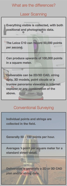
Laser Scanning
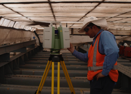
Custom Spatial Solutions has been completing laser scanning projects with our Leica C10 Scanstation since 2010. For an example of some scan data please view the above video of a scan we did at the Festival Centre and Parliament House in Adelaide.
What is a laser scanner?
If you consider conventional surveying to be a 3D line drawing, then laser scanning would be the equivalent of a 3D photograph.
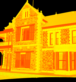
Laser scanning, also known as LIDAR or High Definition Surveying (HDS) utilises a very rapid laser pulse to scan its environment. This generates an enormous number of points in the form of a point cloud. Meshes & DTMs, 3D models, CAD linework and survey strings can then be modelled or extracted from the point cloud.
What benefits can laser scanning deliver?
-
 Better results - Scanning minimises many types of errors and generates more accurate and complete plans and data. Using laser scanning can give a complete view of a site, down to the details of the brickwork.
 -
More cost effective - Because everything visible is located additional site visits can be minimised or avoided altogether, resulting in better project efficiency.
-
Safer - The use of remote data acquisition keeps personnel away from dangerous situations.
-
More informative - Scanning complex geometry, pipes, steelwork, and similar can be the best way to avoid risky field redesigns. Clash detection in the office prior to construction is a much better option than finding the problems on site during construction.
What is laser scanning good for?
Areas where laser scanning can be a more efficient and cost effective choice than traditional surveying methods include:
-
Pipework - for example, refineries. mills, water plants, reservoirs, wineries.
-
Bridges
-
Towers - Mobile phone towers, electricity pylons, etc.
-
Structural steel
-
Architecture - especially complex buildings.
-
Building interiors
-
Road intersections (less risk than traditional methods as the entire survey can be done from the footpath)
-
Stockpiles & volumes
-
Cliffs & areas of hazardous ground.
-
Deformation & slope monitoring
-
Any site where there is a limited time for the survey.
-
Any site where access is limited or unavailable.
-
Any site where multiple site visits may be required.
Can our clients use point cloud data too?
Yes...
Some design software is capable of working directly with the point cloud data and there are plugins available for Autocad and other packages. There is also a free Truview plugin available to view, annotate & query point cloud data in Internet Explorer.
Spatial solutions for a complex world
Limited access? Short time frames? Complex environments?
Maybe laser scanning can provide the spatial data you require.